The Southern Appalachians offer many attractions and enticements, including some of the most ravishing scenery in eastern North America. Here you’ll find the most popular national park in the United States: Great Smoky Mountains National Park. You’ll also find one of the country’s greatest and most challenging drives, a magnet for motorcyclists, sports-car enthusiasts, and other asphalt aficionados. And it’s only about 90 miles west of Asheville.
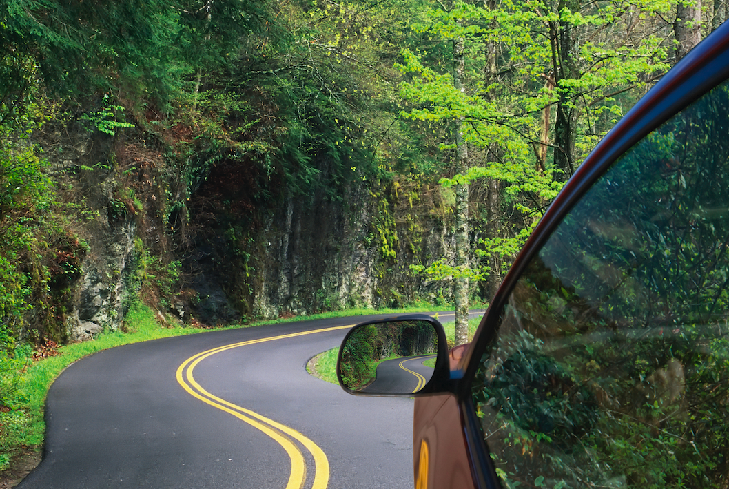
The Tail of the Dragon—or, simply, the Dragon, depending on whom you talk to—offers a famously twisty route through these grand, heavily forested mountains. The scenery is woodsy and lovely, but it actually takes a backseat (if you will) to the driving experience itself. The utter concentration of hairpin turns, double backs, and squiggly tests of your steering-wheel prowess are the main attraction.
What is the Tail of the Dragon?

The exact length of the Tail of the Dragon depends on your definition of the roadway. Most specifically, this drive refers to the incredibly serpentine 11-ish miles of U.S. 129 between Deals Gap, on the Tennessee-North Carolina line, and the Tabcat Creek Bridge at Chilhowee Lake in Tennessee. On the North Carolina side, it encompasses Tapoco Road, while over in Tennessee it’s often referred to as Calderwood Highway.
We’re talking about more than 300 turns in those mere 11 miles. They’re sharp enough to have earned nicknames: Rockslide Corner, Wheelie Hell, Gravity Cavity, The Whip, Brake or Bust Bend, etc.
In terms of natural geography, the Tail of the Dragon runs along with reservoirs of the Little Tennessee River, namely Cheoah and Calderwood lakes. The riverway essentially describes the seam between the Great Smoky Mountains to the north and the Unicoi Mountains to the south. These are some of the highest, most rugged, and most scenic ranges of the Southern Appalachians. In terms of jurisdiction, the Tail of the Dragon edges Great Smoky Mountains National Park and the Cherokee National Forest.
A Snapshot History of the Tail of the Dragon

Photo Credits by @unknownvsoldier on Instagram
Almost undoubtedly, the Tail of the Dragon roughly traces old animal routes—elk, deer, bison—through the Southern Appalachians. As elsewhere, these game trails were surely adopted by indigenous North Americans. The story goes that this foothill traverse was used by a group of Cherokee to escape the forced removal along what’s now known as the Trail of Tears.
Paved in the 1930s, the highway and its exceptional twistiness gradually became better and better known among recreational drivers. By the dawn of the 21st century, it was a genuine motoring destination in and of itself.
You could easily start an argument around these parts about whether the 11-mile stretch in question is most accurately called “the Tail of the Dragon” or simply “the Dragon.” We’re going with the Tail of the Dragon, as that’s the better-known label these days. Either way, this U.S. 129 reach enjoys an association with that mythical, fire-breathing beast, which certainly adds to its aura. You’ll see more than a few dragon sculptures and signboards in the vicinity.
How Much Time Does it Take to Drive?

You’ll want to set aside about a half-hour or so to tackle the Tail of the Dragon. The speed limit is a strict 30 miles per hour, and you definitely don’t want to push it. You could certainly devote more time to the drive, given there are a few pullouts along the way. Besides the scenery, it’s kind of a blast to watch other drivers negotiating the twisty, turny blacktop.
Sights Along the Way

Photo Credits by @ellagibsonmusic on Instagram
At the North Carolina end of things, be sure to check out the Deals Gap Motorcycle Resort. Among other attractions, it includes the Dragon Tree of Shame, which displays wreckage from motorcycle crashes along the drive. It’s funky and also sobering, a good thing to reflect upon before tackling the Tail of the Dragon. Across the way is the Tail of the Dragon Store, a good spot for souvenirs and other knick-knacks.
The Calderwood Overlook in Tennessee provides a stunning vantage of the reservoir behind Calderwood Dam and its dramatic mountain backdrop. If you extend your journey beyond Deals Gap on the North Carolina side, you can check out Cheoah Dam, which you might just recognize from maybe the most famous scene in the 1993 Harrison Ford blockbuster The Fugitive.
Scenically, there’s little question that the Tail of the Dragon reaches its pinnacle come fall when the Southern Appalachian foliage puts on a gobsmacking show.
Nearby, meanwhile, lie some other major regional draws easily rolled into a Tail of the Dragon drive. These include the recreational hotspot of Fontana Lake, the spectacular sightseeing route of the Cherohala Skyway, and the old-growth magnificence of the Joyce Kilmer Memorial Forest.
General Tips & Safety Along the Tail of the Dragon

The most important thing to remember when tackling the Tail of the Dragon is to put safety majorly front and center. Those twists and turns are nothing to play around with, with about one death a year attributed to this legitimately tricky drive. Abide by the 30-mile-per-hour speed limit, and don’t push your own abilities, whatever sort of Indy 500 fantasies you might be indulging in. The tight curves and narrow, up-and-down nature of the road set the stage for disaster if you go the distracted-driver route.
Use the scattered pullouts if you want to take in the vibes and the views—including those flashy cars and roaring bikes weaving along the way. Don’t just pull over at any old place along the shoulder.
Ice and even snow make the Tail of the Dragon a bad proposition in the wintertime. Summer and early fall are best for experiencing it. Weekends, as you might imagine, are crowded, so if you can swing it, try for a weekday excursion.