
“From roaring waterfalls in lush gorges to craggy ridges high above the trees, the Great Smoky Mountains are packed with unforgettable views. In this post, we’ll explore seven of the most impressive geologic landmarks in Great Smoky Mountains National Park —natural wonders that showcase the park’s dramatic geology and unique terrain.”
In this blog, we’re highlighting seven geologic landmarks that help define the park’s rugged beauty. This isn’t a complete list — just a sampling to inspire your next visit.
We’ve left out some famous peaks like Clingmans Dome and Mount LeConte, which are top attractions in their own right. (You can learn more about those mountains in this blog post of ours.) We’ve also skipped the Smokies’ many stunning waterfalls — they deserve their own spotlight!
Now, let’s dive into these must-see natural features, listed in no particular order.
1. Charlies Bunion

Charlies Bunion has one of the more unusual names in the park (right up there with Big Butt and Devils Tater Patch). It’s also home to one of the best views in the Smokies.
This rocky crag sits at 5,565 feet along the Smoky Mountain crest. It’s made up of rocks from the Anakeesta Formation, a mix of slate, phyllite, and metasiltstone. These same rocks appear just northeast of the Bunion along a sharp ridge called the Sawteeth.
The landmark got its name in 1929. Horace Kephart, a writer and Smoky Mountains advocate, joked that it looked like his hiking buddy Charlie Conner’s sore toe. So, yes — it was named after a bunion.
The hike to Charlies Bunion is moderately tough but very popular. It’s 8.1 miles round trip from Newfound Gap on the Appalachian Trail. A 1925 wildfire opened up the view, which is now dominated by Mount LeConte — one of the tallest and most prominent peaks in the Smokies.
2. The Chimney Tops

The Chimney Tops are two dramatic rock spires made of Anakeesta slate. They rise from a ridge off Sugarland Mountain and look down on the West Prong of the Little Pigeon River.
They’re named for the natural chimney-like shafts in their stone. These twin peaks form a rugged, eye-catching spine.
After a wildfire damaged the area, the park service rerouted the Chimney Tops Trail. It no longer goes to the peaks themselves. But the new overlook still offers stunning views of the Chimneys, Mount LeConte, and Mount Mingus.
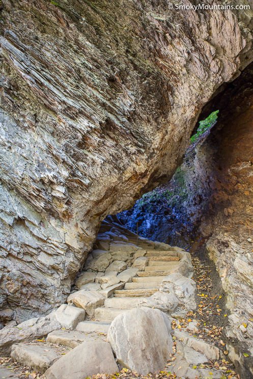
3. The Alum Cave Bluffs

This towering rock wall isn’t a true cave. It’s a huge alcove carved into the side of Peregrine Peak, just south of Mount LeConte. Like the other formations on this list, it’s made from Anakeesta rock.
The Alum Cave Trail, one of the most scenic routes to LeConte’s summit, passes right beneath this bluff. During the Civil War, people mined minerals here like alum and saltpeter, the latter used for making gunpowder.
Winter brings a special sight: giant icicles hanging from the bluff. They’re beautiful, but watch out for falling ice!
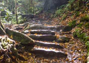
4. Arch Rock
Also along the Alum Cave Trail is Arch Rock: a narrow tunnel through Anakeesta slate. It formed slowly over time through repeated freezing and thawing of water.
Hikers pass through the arch using stone steps and cables. It’s one of the trail’s most unique features and a highlight early in the hike.
5. The “Eye of the Needle”
Yet another gem on the Alum Cave Trail is the Eye of the Needle. From Inspiration Point — and even more clearly just beyond it, you can spot a round hole near the top of Little Duck Hawk Ridge.
This hole was carved by freeze-thaw weathering. It’s easy to miss if you’re not watching for it, so keep your eyes peeled.
This ridge is also a nesting site for peregrine falcons. If you’re lucky, you might spot one soaring nearby, they’re some of the fastest and fiercest birds in the park.
6. Sugarland Mountain

Sugarland Mountain may not be as famous as LeConte or Clingmans Dome, but it’s a beautiful ridgeline in its own right. It runs northwest from Mount Collins and separates the West Prong of the Little Pigeon River from the Little River. This long ridgeline is not only a hiking highlight — it’s also one of the most scenic geologic landmarks in the Smokies.
The ridge tops 5,000 feet and narrows to a knife-edge in spots. It’s a quiet, rugged part of the park.
The Sugarland Mountain Trail stretches 12.1 miles and is a great backcountry adventure. Hike it as a shuttle route — from the Fork Ridge Trailhead (off Clingmans Dome Road) to the Laurel Falls Trailhead (along Little River Road).
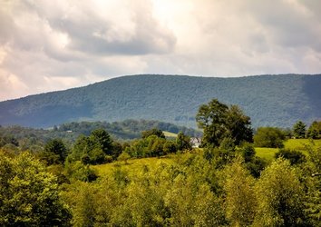
7. Cades Cove

Cades Cove is one of the most visited areas in the park. People come for its beauty, wildlife, and historic buildings, but it’s also a geologic marvel.
Cades Cove is a tectonic window. That means erosion wore away older rocks to reveal younger limestone layers below. These limestone soils are rich and fertile, making the cove ideal for farming.
This valley, ringed by mountains, was once a remote and wild place. Settlers moved in during the early 1800s, drawn by its open land and natural resources.
(You can read more about the history of Cades Cove in this blogpost.)
Explore the Geologic Landmarks of the Great Smoky Mountains
Many of the Smokies’ rocks are hidden beneath dense forest or rich soil. But look closer, and you’ll find geologic wonders throughout the park. These geologic landmarks in Great Smoky Mountains National Park tell the story of millions of years of mountain-building, erosion, and uplift. From high crags to limestone valleys, these features help shape the dramatic landscape that draws millions of visitors every year.